
Anna Ruby Falls
Site History
The Story of Anna Ruby Falls
Long before there was a visitor center, paved trail, or observation deck, water was shaping this corner of the North Georgia mountains. Today, Anna Ruby Falls is known as one of the region’s most memorable natural destinations, but its story reaches beyond the view from the falls. The landscape, waterways, and surrounding forest all reflect a much longer history that continues to shape the visitor experience today.
It is a story shaped by two mountain streams, the family behind the name, the deeper history of the Sautee Nacoochee Valley, the creation of protected public lands, and the partnerships that continue caring for the site today. Together, these connections help explain not only how Anna Ruby Falls came to be known, but why the surrounding landscape remains so meaningful to the people who visit and care for it.
The Landscape Behind the Twin Falls
Anna Ruby Falls is formed where Curtis Creek and York Creek descend side by side through the Blue Ridge Mountains. Curtis Creek drops approximately 153 feet, while York Creek falls approximately 50 feet. The two streams meet at the base of the falls and continue through the forest as Smith Creek.
This meeting of two waterways creates the distinctive twin-falls view visitors see from the observation decks. Along the trail, Smith Creek, smaller cascades, moss-covered rocks, ferns, wildflowers, and shaded forest scenery introduce the natural story of the site before visitors reach the main falls.
The landscape also reflects the importance of mountain watersheds. Forested slopes help protect streams, reduce erosion, provide wildlife habitat, and support the waterways that continue beyond the recreation area.
Anna Ruby Nichols and the Name
The falls are named for Anna Ruby Nichols, daughter of Captain John H. Nichols, whose family once held extensive land throughout the surrounding mountain region.
Captain Nichols purchased nearly 2,600 acres in the area in 1869, including land associated with present-day Anna Ruby Falls, Hardman Farm, and portions of the surrounding mountain landscape.
Legend has it that Captain Nichols and his daughter were exploring the property on horseback when they came upon the waterfalls, which he later named in honor of Anna Ruby. While the horseback discovery story has been passed down through generations, it is best understood as local legend rather than a documented account of the falls being “discovered.”
The Nichols family’s connection to the area remains visible at nearby Hardman Farm State Historic Site, where the family home has been preserved and Anna Ruby’s former bedroom is included in guided tours.
Anna Ruby Nichols was not simply a name added to a map. She was a real person whose family history remains part of the broader story of the Sautee Nacoochee Valley.
A Longer History in the Valley
The human story of this landscape began long before the Nichols family. Indigenous peoples lived throughout the southern Appalachian region for generations before European settlement.
Archaeological and historical evidence connects the surrounding area with Mississippian peoples, Muscogee (Creek) communities, the Cherokee, and other Indigenous groups who lived, traveled, traded, and established communities throughout the region. The nearby Nacoochee Mound remains one of the most visible reminders of this much earlier history.
Nearby Hardman Farm also preserves a section of the historic Unicoi Turnpike. The route developed from an earlier buffalo trail and Native American trading path before becoming an important road through the mountains.
During the nineteenth century, settlement, mining, logging, and the forced removal of Indigenous peoples dramatically changed communities and landscapes throughout North Georgia. These changes became part of a much broader regional story that eventually included forest restoration, watershed protection, and public-land conservation.
From Mountain Land to National Forest
During the late nineteenth and early twentieth centuries, logging expanded throughout the North Georgia mountains. Timber companies worked portions of the surrounding region, including areas near Anna Ruby Falls, as demand grew for lumber and other forest products.
Eastern hemlock trees were also valued for tannins found in their bark, which were used in leather production. Although the steep terrain surrounding the falls limited some logging efforts, large portions of North Georgia’s forests had been heavily cut by the early twentieth century.
The Weeks Act of 1911 allowed the federal government to begin purchasing land in the eastern United States to protect forests and important watersheds. The U.S. Forest Service acquired the land surrounding Anna Ruby Falls in 1925 as part of the growing effort to restore and protect the region’s forests.
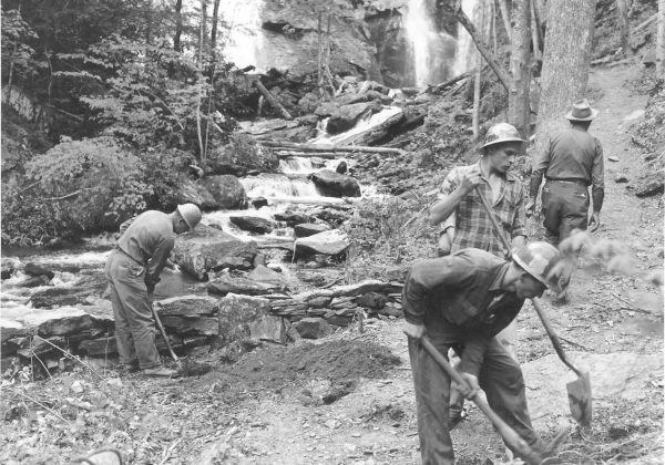
During the 1930s, the Civilian Conservation Corps became another important part of that restoration story. CCC crews worked throughout North Georgia on conservation, erosion control, road construction, trails, and outdoor recreation projects. Their work also contributed to early visitor improvements around Anna Ruby Falls, including bridges and benches along the route to the falls.
The Chattahoochee National Forest was formally designated in 1937. As forests recovered and public recreation expanded, places such as Anna Ruby Falls became destinations where visitors could experience protected mountain landscapes through trails, viewing areas, interpretation, and visitor services.
The paved trail, observation decks, picnic areas, and visitor facilities have since welcomed generations of families, students, hikers, and travelers. These improvements also allow visitors to enjoy the landscape while remaining on designated routes that help protect Smith Creek, the forest floor, and surrounding habitat.
The Lion’s Eye Trail and Community Partnership
One of the site’s most meaningful additions is the Lion’s Eye Trail, dedicated in 1987 through a partnership involving the Chattahoochee National Forest, local Lions Clubs, volunteers, and community supporters.
Located near the visitor center, the short paved trail was designed to provide a richer forest experience for visitors with visual impairments. A cable handrail helps guide visitors between interpretive signs presented in standard text and braille.
Although the Lion’s Eye Trail does not lead to the waterfalls, it offers a close connection to Smith Creek and the surrounding forest. Its story shows how cooperation among public agencies, local organizations, volunteers, and community members can make outdoor experiences more welcoming and meaningful.
Caring for Anna Ruby Falls Today
Anna Ruby Falls is located within the Chattahoochee-Oconee National Forest and is operated by FIND Outdoors in partnership with the U.S. Forest Service. FIND Outdoors (previously known as the Cradle of Forestry Interpretive Association) expanded its work into North Georgia in the early 2010s, including operations at Anna Ruby Falls and Brasstown Bald.
Today, this partnership supports the visitor center, gift shop, trails, observation areas, educational programs, seasonal events, and everyday visitor experience. Through recreation, education, and stewardship, Anna Ruby Falls continues helping people build a stronger connection with North Georgia’s public lands.
Every visitor becomes part of the next chapter. Staying on designated trails and observation decks, respecting wildlife, leaving natural and historic features undisturbed, and following posted rules all help protect Anna Ruby Falls for those who visit next.
→ Explore Hardman Farm State Historic Site
→ Learn More About FIND Outdoors