
Carolina Hemlocks
Surrounding Area Information
Discover Burnsville and the Black Mountains
Carolina Hemlocks Campground & Recreation Area is surrounded by some of Western North Carolina’s most memorable mountain scenery. Located along the South Toe River in Pisgah National Forest near Burnsville, the recreation area and campground is easy to pair with nearby public lands, scenic drives, mountain communities, and other outdoor destinations.
Whether you are staying for a weekend or building a longer trip through the mountains, Carolina Hemlocks provides a convenient base for exploring more of Yancey County and the surrounding Black Mountains.
Burnsville and Nearby Mountain Communities
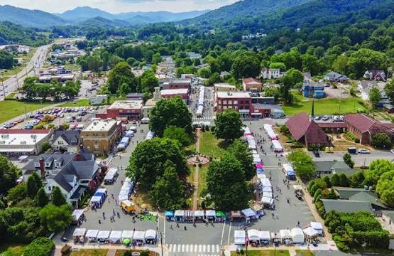
Burnsville is the closest major town to include in a Carolina Hemlocks trip. Located north of the campground, the town can be a convenient stop for food, fuel, camping supplies, visitor information, or time exploring the downtown area.
Burnsville sits in the shadow of Mount Mitchell and serves as a gateway to many of the outdoor recreation opportunities found throughout Yancey County. The downtown Town Square also provides a central gathering place for community events and local activities.
Visitors planning a longer stay can stop by the Burnsville Visitor Center for maps, regional information, and help learning more about nearby attractions and recreation opportunities.
Explore the South Toe River and Pisgah National Forest
The South Toe River is one of the defining features of Carolina Hemlocks and the surrounding area. Beyond the campground, the river continues through a forested mountain landscape that supports fishing, swimming, tubing, wildlife habitat, and other outdoor recreation.
Pisgah National Forest surrounds much of the region and provides access to hiking, scenic mountain roads, waterfalls, rivers, and high-elevation landscapes throughout the Appalachian Ranger District.
Road, trail, and recreation-area conditions can change because of weather, maintenance, or repairs. Visitors should check current U.S. Forest Service information before traveling to another recreation area or trailhead.
Visit Mount Mitchell State Park
Mount Mitchell State Park is one of the most recognizable destinations in the region and makes a memorable addition to a Carolina Hemlocks trip. At 6,684 feet, Mount Mitchell is the highest point east of the Mississippi River. Visitors can explore the summit area, walk to the observation deck, enjoy high-elevation forest scenery, picnic, or choose from several hiking trails within the park.
Conditions at the summit can be much cooler, windier, and foggier than at Carolina Hemlocks, even during summer. Bring an extra layer and check current weather and park information before making the drive.
Mount Mitchell State Park is managed separately from FIND Outdoors and has its own operating information, facilities, trail conditions, and seasonal notices.
Drive the Blue Ridge Parkway
The Blue Ridge Parkway offers another way to experience the mountains surrounding Carolina Hemlocks. The scenic roadway travels through the Black Mountains and provides access to overlooks, trailheads, high-elevation forests, and Mount Mitchell State Park.
Parkway conditions can change because of weather, construction, storm recovery, or seasonal closures. Some sections may require lengthy detours even when nearby destinations appear close on a map.
Visitors should check the current National Park Service road status before planning a Parkway drive, especially when traveling toward Mount Mitchell or other destinations north of the park.
Explore the Night Sky at Mayland Earth to Sky Park
Mayland Earth to Sky Park near Burnsville offers a different way to experience the natural landscape of Western North Carolina.
The park includes the Bare Dark Sky Observatory, Glenn and Carol Arthur Planetarium, gardens, educational spaces, and opportunities to learn about astronomy, environmental science, and the night sky.
The Bare Dark Sky Observatory is home to a large public telescope and offers scheduled community viewing nights. Observatory access is available during ticketed programs, while the park also provides opportunities for independent stargazing when conditions allow.
Because programs, ticket requirements, and operating hours vary, visitors should review current Mayland Earth to Sky Park information before planning a visit.
Experience Local Mountain Culture
The Burnsville area combines outdoor recreation with a strong connection to the culture and communities of the North Carolina mountains.
Visitors can spend time around the Burnsville Town Square, learn more about local mountain heritage, explore community events, or use the town as a starting point for discovering additional destinations throughout Yancey County.
Plan Ahead Before Exploring Nearby Areas
Each nearby destination is managed separately and may have its own operating hours, parking information, fees, reservations, pet policies, road conditions, and seasonal closures.
Mountain travel can also take longer than expected due to winding roads, changing weather, and limited cell service. Blue Ridge Parkway or Forest Service closures can also significantly affect travel times.
Before leaving Carolina Hemlocks, check current information directly with the agency or organization responsible for the next place you plan to visit.
→ Explore Burnsville and Yancey County
→ Explore Mount Mitchell State Park
→ Check Blue Ridge Parkway Road Conditions
→ Check Pisgah National Forest Alerts
→ Explore Mayland Earth to Sky Park